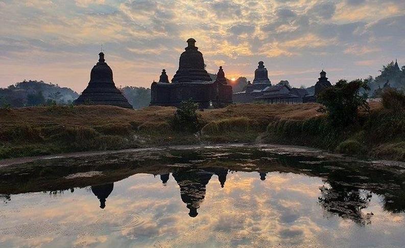
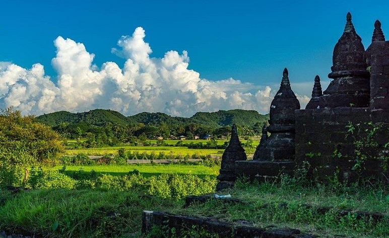
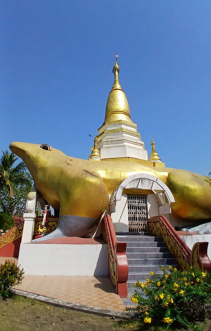
The Shitthaung Temple is one of the most renowned temples in Mrauk U. It was established in 1535 by King Min Bar Gyi, the most powerful Rakhine king of Mrauk U Period . It is so named because it housed 8,4000 images of the Buddha to be enlightened in the future.
King Min Bar Gyi ascended the Mrauk U palace in 1532. Three years afterwards, the Portuguese soldiers who were based on Sundvipa island at the mouth of the Ganges river invaded Rakhine territory with a great navy. But the Rakhine army defeated them and drove them away out of their domain. In commemoration of that victory , King Min Bar Gyi built this temple. So it was also known as ‘ Yan Aung Zeya Temple’.
Having sought advice from Sayadaw Vens. Aggacideya and Aggamuni, Hermit U Mra Wah ,wise Minister Vimala and his son Maha Panna Kyaw, the king had the Phoe Khaung hill one kilometer north of the palace bulldozed and levelled and the temple built on that ground by 1,000 masons within one year.
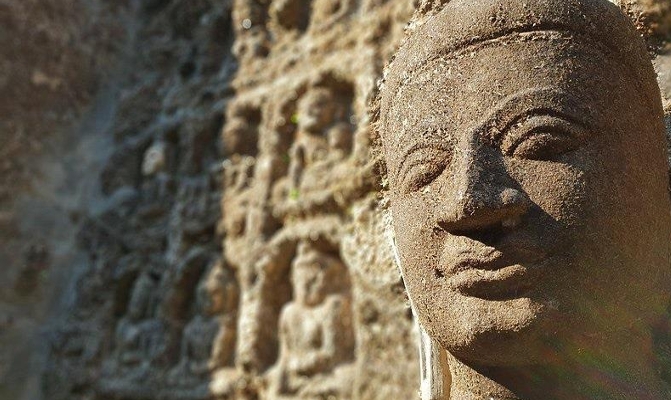
The Shitthaung Temple is the archaeological treasure house which ranks top in Mrauk U. Its roof is surmounted with a large bell-shaped stupa surrounded by 26 satellite stupas. The outer wall is interspersed with twenty-eight niches in which are life-size images of the seated Buddha placed back to back. All life-size reliefs at this temple represent King Min Bar Gyi as the earthly counterpart of Sakka, King of gods who resides in Tavatimsa on the Summit of Mount Meru. The six tiers of bas reliefs at this temple may correspond to the six planes of existence. The lowest level of the reliefs depicts animals of all kinds, humans, etc enjoying life in the world of desire. The central level depicts the former lives of the Gotama Buddha from the jataka tales that give the moral lessons to all visitors. The Lokapalas Devas are depicted at the fifth level. The uppermost level represents Brahmas or gods. At the four corners, the reliefs are interspersed by life-size statues which represent King Min Bar Gyi.
At intervals around the plinths are figures of the earth goddness Vasundhare wringing her hair to bear witness to the Danaparami (Perfection of donation) fulfilled by the Budhisatta. Byala, a mythical creature, which is the national emblem of the Rakhine, is found inside of the Shit-thaung Temple. The Rakhines regard it as a symbol bringing good luck and auspiciousness to them.
The Shit-thaung temple festival is one of the most popular festivals in Rakhine. The festival usually falls on May 23 and last five days. Rakhine traditional long- boat races, Rakhine Kyin Pwes( the Rakhine traditional wrestling contests), Rakhine traditional dances and Buddha Pujaniya ceremony are held during the festival. During the festive days, the pilgrims from far and near flock to this festival. So the whole town is alive and agog with festive mood from the sun-rise to sun-set.
During the Buddhapujaniya ceremony, beautiful Rakhine damsels perform the Rakhine traditional dance in praise of the attributes of Triple Gem. These dances show great devotion of the Rakhines to Buddhism from the ancient times.
In the long-boat race, 10 boats have to participate, each group comprising 15 strong, muscular long-boat rowers. Many spectators on both banks of the creek applaud the contesting rowers. This race show the unity and outstanding rowing skill of the Rakhines. In Kyin pwes, the Kyin wrestlers who come from Tawphyanchaung area in Ponnagyun Township and Yanbye Township are famous and mostly win many trophies. This race shows quickness, mindfulness, stamina and art of the wrestling . Rakhine nationals take much pride in this sport as a national identity and they desire to preserve Kyin wrestling as an ancient Rakhine sport .
To conclude, the Shitthaung Temple is the show-case of the Buddhist art and architecture. So it reflects the high architectural standard of ancient Rakhines and their profound devotion to Buddhism. Like this temple, other pagodas and temples in Mrauk U are embellished with excellent works of art and architecture. So it is thought by the writer that all the temples and pagodas in Mrauk U including the Shitthaung Temple should be kept in situ.
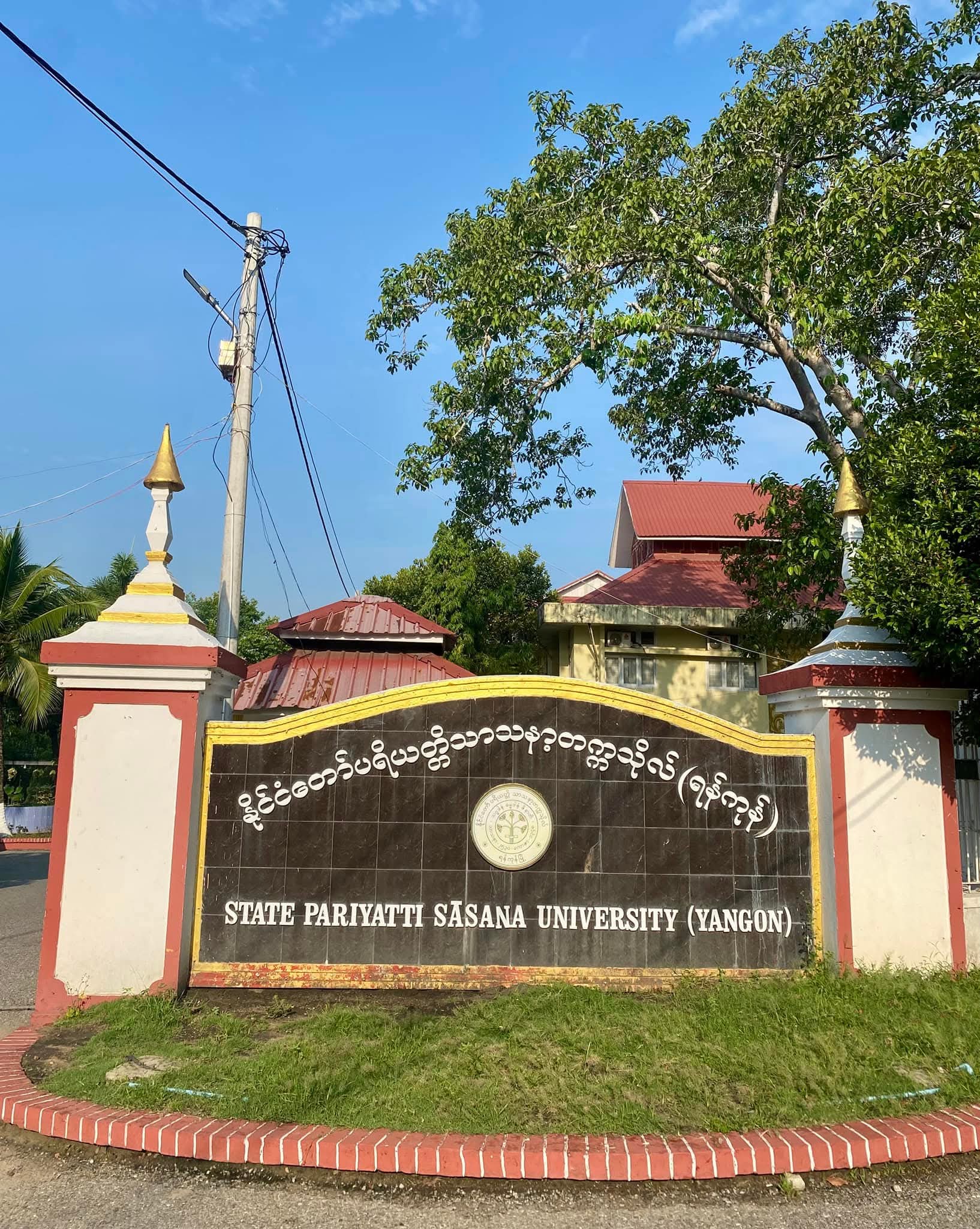
It was a balmy morning. The bright rays of the sun, through the thick foliage of trees, were beaming down on the cars we would board. I stood near the Mogok Refectory in the precincts of State Pariyatti Sasana University, looking at the spire of the glittering Kaba Aye Pagoda that stood majestically. I saw the leaves of the Bodhi tree and toddy palms on the platform swaying due to the wind. Soon, we were ready to leave the Mogok Refectory.When our minibus set out, it was around 8 am. Our group was comprised of 12 people: 8 monks from the State Pariyatti University (Yangon) and 4 lay persons, including myself and my elder brother. Our destination was Thongwa, a small town near Yangon, and on our arrival there, we would attend the 80th birthday celebration of Rector Sayadaw Dr Bhaddanta Kumara. Moreover, we would honour the Sayadaw who had recently received the esteemed religious title ‘’Abhidhaja Maharatthaguru “conferred upon him by the State.Our car departed from Kaba Aye Pagoda Road towards Gandama Road. Soon, we reached the junction at which Okkalapa Golf Resort is situated. After passing through Inno City Buildings, our car ran quickly along Waizayanta Road without any halt until we reached the newly constructed Thanlyin Bridge. At 8:45 am, we crossed the toll gate of the bridge. I gazed at the turbulent Yangon River flowing below. I saw some seagulls floating with the current, a fleet of cargo ships at anchor in the middle of the river and one or two motorboats moving fast. I looked towards a hill where the Lwan Ceti is situated on the other bank. Instead of the Ceti, I saw just a small hill clad in the green rainforests and some buildings in the neighbourhood. The Ceti was hidden amongst the groves of leafy trees.Having passed through Aung Chantha Junction, we turned right and proceeded along Kyaikkhauk Pagoda Road. We saw the colonial buildings, ancient buildings, etc. It suggests that it was an ancient town. Legend has it that Thanlyin was so named after Maung Thanlyin, who founded it, while it derived from ‘’Mya Thanlyin”, a princess who ruled over it. But their times could not be traced back exactly. It was a garrison town of the Portuguese during the Nyaung Yan period. It developed a district-level town stationed by an assistant commissioner during the colonial period. Soon, we got to Thanlyin Myoma Market. The marketplace was in commotion. It was buzzy with many buyers, sellers, etc. I saw some motor-trishaw drivers under a big, branchy tree. Shops and mini-stores were tucked in the buildings on both sides of Myo Ma Market. At 9 am, we reached the foot of Uttaringa Hill, at the top of which, the historic Kyaikkhauk Pagoda stood majestically. Our car turned left onto a road leading east. Soon, we saw Yangon Eastern University on a wide estate sheltered by the green leafy trees. It is learnt that it was built in 1999. It offered young people in the neighbourhood access to higher education. At 9:04, we arrived in front of the eastern archway gate. Nevertheless, we proceeded nonstop. Soon, we were outside the town and continued along the No 6 Road, which is the main road towards Thongwa.The traffic became lighter. Some cars overtook ours in a tearing rush. The further we moved, the more countrified the scenes became. We often saw wide fields, small hamlets, and dense forests. Some monasteries, sprawling plantations and vast pea fields were found on the road-sides until we arrived at Thaik Tu Kan Model Village. We proceeded along the No 6 Road. There were petrol stations, Kokku trees and a home for the aged on the roadside. Rice granaries and pea-storage warehouses stood prominently, reflecting the area’s agricultural livelihood.We then passed the Mahasi Meditation Centre, a testament to the villagers’ deep religious devotion. Nearby, a middle school stood as a symbol of education in the community. Soon, we entered downtown Thongwa, a historic town established during King Thayawady’s reign. Its name derives from its location at the confluence of the Mawwam Creek, the Thenegi Creek and the Takaw Creek. During the colonial period, Thongwa was a district-level town. It was administered by the assistant commissioner. People were generous and pious. Thus, they made many donations. Religious buildings, monasteries and pagodas, etc., were, therefore, found in abundance. It was a thriving town, bolstered by fisheries and agriculture.Some colonial-era wooden buildings are still extant. As soon as we crossed a bridge that spanned a small creek, we arrived at the bustling municipal market in the downtown. Turning left, we finally reached our destination, Sayadaw U Kumara’s monastery ‘’Thel Inngu Yeiktha Sasana Aung Beikman’’ at 9:36 am.When we arrived there, we took photographs and rested in the Sayadaw’s room. Some of his lay devotees treated us to tea-leaf salad and snacks. Soon, they led us to a refectory and served lunch. The courses of meals were many and delicious. Guests were house-full. While lunching, some devotional songs were heard, coming from a wide hall. After lunch, while passing through this hall, I noticed heaps of four requisites in it. It is known that by drawing lots, the monks would be offered these requisites soon. I saw some guests watching the vocalists on the stage singing classical songs, devotional songs, etc., in honour of Sayadaw’s obtaining the recent title and 80th birthday.When we arrived again at the Sayadaw’s room, we met him readily. We paid respect to him. We had a chat with him. He presented me and other teachers from State Pariyatti University, some of his authored books, and during our conversation, some local devotees arrived to present offerings. As far as I know, Sayadaw is currently serving as Rector of the State Pariyatti Sasana University (Yangon) and as Presiding Monk of the Maha Sima Pariyatti Monastery and the Everest Dhamma Yeik Nyein Monastery. On January 1, 2025, the government honoured him with the religious title ‘Abhidhaja Maharatthaguru’. He, as a distinguished scholar, earned his PhD in Buddhist Studies from Maha Chulalongkorn Rajavidyalaya University in 2023. His other titles included Aggamahapandita, Mahaganthavacaka Pandita, Aggamaha Saddhammajotikadhaja, and Honorary Dhamma Paragu (Litt), along with the Thiri Pyanchi Performance Award. He was also a prolific writer and had authored numerous works on Buddhist scriptures.On our way back, we took a different route, passing the Kularwe Bridge. We enjoyed the new scenes again. We saw gardens, resorts, and sprawling fields stretching on either side of the road. Due to the beautiful scenery, we felt refreshed and peaceful. We obtained new regional knowledge, for I had never been to Thongwa before. Moreover, we obtained merits because we had to worship Sayadaw and monks. Thus, it was a rewarding and profitable trip for us.Source: GNLM
Contined from yesterdayHiking and a manmade beach at Titop BeachAfter finishing the Sung Sot cave tour, the Stella Luxury Cruise continues on the second trip to Titop Island. Titop Island is famous for its hiking trail and manmade sandy beach. The path to the top of the mountain is narrow and steep, and it takes about 20 minutes to reach the summit.From the top of Titop Mountain, you can enjoy wide panoramic views of Ha Long Bay. Therefore, many travellers prioritize the mountain climbing trip. Upon reaching the summit, visitors can see the most beautiful expansive views of Ha Long Bay, along with breathtaking scenes of large limestone rocks emerging from the water’s surface and the surrounding islands. These scenic views make it one of the best places for photography enthusiasts.At Titop Beach, the sea water is cool and clear with a deep greenish-blue colour, and the soft white sand allows travellers to relax and unwind. Many swimmers and snorkelers can be seen, as well as hikers on the hills nearby. The entire island is bustling with walkers and photographers. Since it is a manmade beach, natural dunes are not present, so the waves and the white foam running over the dunes you might expect at a natural shoreline are absent here.Although the sea breeze and the green coconut trees, which are the distinctive features of the sandy beach, are not seen together, green coconuts are being sold at a small shop in one place. Since it is a manmade beach, it cannot compete with nature, but it cannot be denied that it is a beautiful island in the sea.Ha Long Bay, one of the world’s seven most beautiful baysFrom Titop Island, the Stella Luxury Cruise is heading back to the shore to go on its third trip to the main destination, Ha Long Bay. When Stella arrives at the shore, passengers must transfer to speedboats to go to Ha Long Bay. As the small speedboat carrying about 15 passengers, including the guide and the speedboat driver, departs from the shore, it begins to rain again.It rained off and on all day, so my mood got a little disturbed. For those who prepared sunglasses and big hats to go to the beach, the rain became the villain.Ha Long Bay is located in Ha Long City, Quang Ninh Province, Vietnam. Recognized by UNESCO as a World Heritage Site, Ha Long Bay is famous for its serene and beautiful limestone karst formations. It covers an area of 1,553 square kilometres and is made up of about 2,000 islands and islets, most of which are limestone mountains formed around 500 million years ago.Ha Long Bay, which attracts over one million international tourists annually, is an important destination in Vietnam’s tourism sector. With nearly 2,000 limestone islands set against a blue sky backdrop, Ha Long Bay, known for its jade-green waters, was designated a UNESCO World Heritage Site in 1994 and has become one of the most beautiful places in the world.The speedboat we are on is heading towards the sea channel through the rain and water. Above the sea, where the sky is cloudy with shades of green and blue, there are many limestone mountains and small islands visible, which are a unique attraction of the Ha Long Bay sea channel. Most of the rocky areas are covered with monsoon forests, making the entire environment lush, green, and truly beautiful.Inside the sea, large cargo ships anchored near the reefs can be seen alongside fishing boats. The Ha Long Bay, bordered by beautiful limestone mountains, looks like a magnificent and unique painting…. We need to study it in the Vietnam water border trade area. The speedboat carrying foreign tourists, navigating swiftly over the water between the rocks to the Chinese border, shows a little boy who seems somewhat tired.Heading to the most beautiful rocky cliffs in Ha Long BayAfter returning from the stormy sea, drenched by rain and wind, we will head to the final destination, the rocky cliffs of the ocean, using canoes and large wooden boats to closely explore the area.Even in the drizzle, travellers ventured out — some heading towards the open sea on speedboats, others making their way to the massive rock formations in large wooden boats or canoes. The pier along the beach became a lively scene, teeming with people of all kinds and boats of all colours, reminiscent of bees swarming around flowers. The sea, muddy brown, was rough and choppy toward the open ocean, but appeared calm and still like a lake near the rock formations — a stark contrast. As the large boats steered toward the giant rocks, the joy and excitement of the diverse group of travellers became contagious and deeply felt.A large boat carrying Chinese tourists in matching outfits was seen rowing towards the rocky outcrops, singing songs in unison. At one point, a boat with young Indian children singing songs also appeared. Out in the water, two people were seen paddling small canoes, swaying gently. Rather than a sea, the place looked more like a large lake surrounded by rocky cliffs.Not only Chinese and Indians from Asia but also travellers from countries like France and the UK can be seen gathering together on separate boats. When the large boats travelling from the beach to the rocky islets and those returning from the rocks pass close to each other, they greet one another with loud shouts and waves. Witnessing these scenes reminds me of the way water-splashing trucks used to cheer and shout greetings to one another during Thingyan in Yangon. If one is prone to nostalgia, then surely the shadows of the past are full of things to long for.In one spot beneath the water’s surface, you can see a large, white, jelly-like jellyfish floating close to the boat. Between the rain-soaked cliffs, the sea is calm, with a deep, cool green hue. Among the rocks and stones, lush green trees growing in the crevices catch the eye. Ha Long Bay, one of the most beautiful bays in the world, was included in the New Seven Natural Wonders of the World list in 2012. Ha Long Bay is home to 14 species of flowers and over 60 species of wild birds and animals.The way back homeWhen returning from the stone caves, Stella will go out to host Vietnam’s famous coffee, while enjoying the beauty of the sunset over Halong Bay. However, the rain, which had been falling and stopping since morning, did not allow a view of the beautiful sunset over Ha Long Bay.We had to settle for watching the rainy evening beauty of Ha Long Bay from Stella, through the gaps between the clouds. Although Stella’s upper deck was designed to offer the best view of the bay at sunset, the rain followed its unrelenting script, and we ended up spending the whole day in the dining hall on the lower deck.The return journey from the beach was accompanied by rain. By exactly 6 am, the vehicles were ready to depart for Hanoi. On this gloomy day, amid the falling raindrops, the travellers from Ha Long Bay seemed a bit melancholic, as if they missed the sea. As usual, the cars made a short stop at a large shopping centre that was connected to a food court along the road.Driving along the highway, passing through lush green fields and major expressways, we arrived back in the Old Quarter of Hanoi as dusk fell. From the car, we caught a quick glimpse of the beautiful Hoan Kiem Lake, glowing with multicoloured lights. Around the lake, the area was bustling like a night market. In the middle of the lake sits a small island known as Jade Island, home to the famous Ngoc Son Temple. A bright red wooden bridge, known as The Huc Bridge, connects the temple to the lakeshore. Both the lake and the temple are among Hanoi’s iconic landmarks. Although Ngoc Son Temple and the vivid red Huc Bridge are not far from the hotel, we didn’t have time to visit them.Some shops in the area of Chinatown are quite similar to the Chinatown in Yangon, closing around 9 pm, but the small roadside stalls remain open until about 10 pm or 11 pm. After returning from the beach and passing through southern Chinatown, there aren’t as many motorbikes as in the morning, but a few still zip by now and then. With fewer motorbikes, more cars can be seen on the roads. On the streets, international tourists are still walking around here and there.In the Chinatown area, signs written in English are quite rare. Notably, only large coffee shops, hotels, and travel agencies display signs in English. Along one street, you can find a travel agency office about every block. The number of international tourists coming to Vietnam is also increasing year by year.Last year, the number of international tourists who visited was 14.8 million, with more than 2 million tourists coming from Europe and America. I believe that a key factor in the success of the tourism industry cannot be achieved without leveraging the high proficiency of Vietnamese youth in the English language.Acknowledgement: To be able to write this piece, I am very grateful to my elder brother Ko Kyaw Kyaw Than and his wife Ma Mee Mee from the UK, who supported and arranged the entire trip from start to finish; also to my elder sister Ma Win Win Than, my younger sister Ma Yi Yi Than, and my wife Ma Nwe Nwe Than, who took care of and assisted throughout the journey; and especially to Ma Mee Mee, who took and supported many documentary photographs, I express my special thanks.GNLM
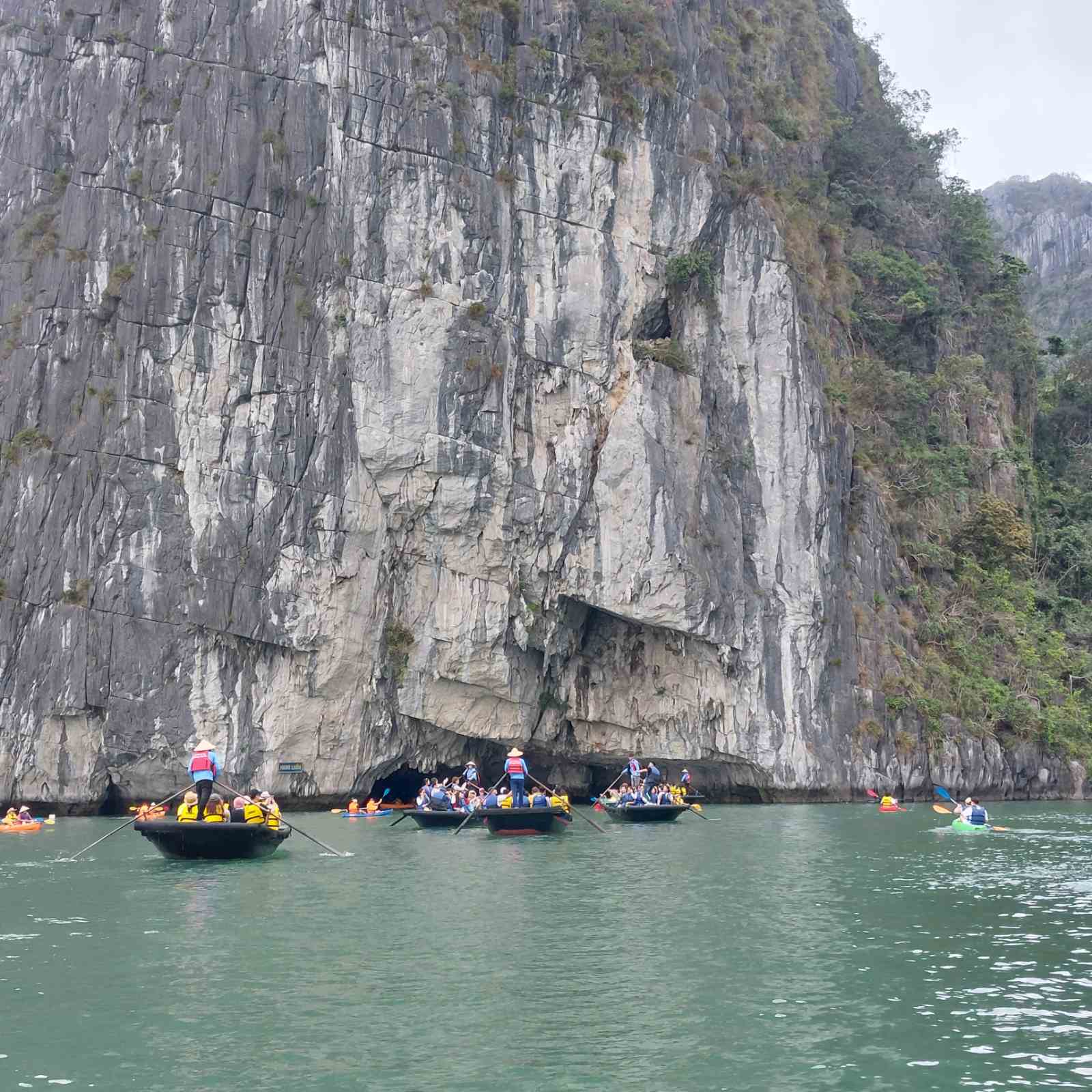
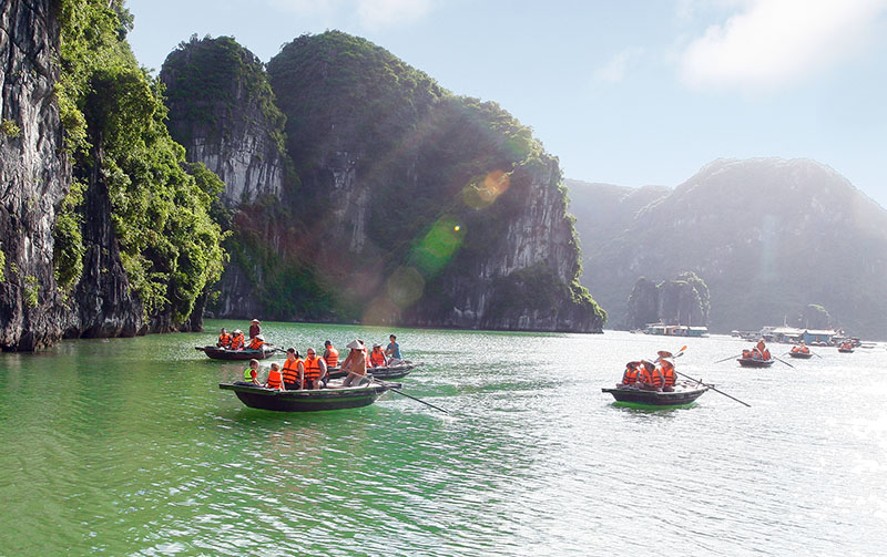
Going to the ocean in the morning with drizzle feels like a unique and different experience. By the time we left the Chinatown area in the old quarter of Hanoi, the drizzle had turned into a steady rain.The Chinatown in old Hanoi, Vietnam, is similar to Yangon’s Chinatown, but the structure and style of the houses are noticeably different. The homes are narrow in the front and stretch deep toward the back, typically no more than three stories high. According to local tradition, if a son is born, a ten-foot-wide plot is inherited, so these narrow, ten-foot houses can often be seen, similar to some homes in areas like Thakayta, South Okkalapa, and Dagon Myothit (South) townships in Yangon. Narrow alleys, compact homes, small eateries lining the streets, large coffee shops, swarms of motorbikes zipping back and forth, and a variety of cars emerging from every corner – these are likely iconic scenes that define Hanoi’s Old Quarter Chinatown.Leaving behind Chinatown, as we ascended onto the highway, the sight of the grand and beautiful new city of Hanoi, with its towering buildings, immediately captivated my attention. Putting aside the multilayered roads and colourful cars of Hanoi, as our vehicle cruised toward Ha Long Bay, my gaze was once again drawn to the expansive green fields stretching alongside the highway, where the vast, serene sea seemed to merge with the lush landscape.Behind lush paddy landscapesIn the distance, across the vast fields spread like green carpets, neat and beautiful little buildings can be seen arranged in order. Among the wide fields, groups of rice mills, silos and agricultural machinery can be seen scattered throughout. The wide, continuous stretches of farmland, the small production roads, and the irrigation drains present a scene so orderly and well-organized that it looks like a carefully drawn map of an agricultural landscape.In Myanmar, it’s not easy to come across vast stretches of farmland laid out in large, rectangular plots like those measured in hectares. Most genuine Myanmar farmers own less than five acres of land, so it’s rare to see large, contiguous plots suitable for big tractors to operate efficiently. For such systematically organized farmland to emerge, challenges such as the need for a stable market, favourable weather conditions, and other hurdles must be overcome. Behind the lingering question of “When will all this become a reality?” lies only a sense of quiet contemplation.Behind the lush green rice fields, Vietnam’s rice cultivation and production are facing mounting challenges. Vietnam’s rice trade is also showing notable developments. In 2024, Vietnam became a record-breaking rice exporter, shipping 9.04 million tonnes. According to the US Department of Agriculture’s (USDA) global agriculture, supply, and demand forecast report, Vietnam is set to soon surpass Thailand to become the world’s second-largest rice exporter.Many rice farmers in Vietnam are switching to cultivating other, more profitable crops, which has led to a decline in the country’s rice production. However, Vietnam’s rice exporters are maintaining their hold on the global rice market by importing rice from neighbouring Cambodia. As a result, by 2024, Vietnam could reach an import volume of around 4 million tonnes, potentially becoming the second-largest rice-importing country in the world. This situation, being both the second-largest rice exporter and the second-largest rice importer globally, highlights a unique aspect of Vietnam’s rice trade.A glimpse of the land of PearlWhen the vast farmlands that once captivated the eye began to fade away, the shimmering reflection of silver light appeared, signalling the arrival at the seaside. This gave a clear sense that we had entered the coastal region. “Ha Long” was once a region known for its coal mines. Along the way, we passed through large areas where hundreds of coal transport trucks used to park. But when international tourists began to arrive at Ha Long Bay, the coal mines gradually shut down, and the entire area appeared to have transitioned to tourism. Now, as a coastal city, Ha Long is also thriving economically through its port operations and fishing industry, becoming a well-known and prosperous city.Ha Long is famous not only for its coal mines, ports, and fishing industry but also for its pearl farming. Pearl farms built in the middle of the sea, artificial islands, and museums that display the step-by-step process of pearl cultivation and production attract many tourists.It has only been two hours since leaving Hanoi. Although the drizzle has stopped, puddles from the rain remain. Upon entering the Ha Long area, the car made a brief stop at a place that houses restaurants, a pearl sales hall, and a pearl museum.What is remarkable is that inside the pearl sales showroom, the pearl production process is demonstrated using small display tables. The process of extracting pearls from oysters and the step-by-step production stages are practically shown, with staff explaining everything clearly. Within the three-story building, there is a large shopping centre that includes gemstone and pearl showrooms, pearl-themed paintings and sculptures, clothing, shoes, and a wide variety of food items. In one section of the shopping centre, there is even a display where crocodile skin is shown with the actual shape of the crocodile, and various types of bags made from crocodile skin are exhibited and sold. As for the dining area, it is located entirely on the second floor.Having just left the Pearl Museum, we soon arrived at the world-famous Ha Long Bay. It has been over two hours since leaving Hanoi. Although we were glad the rain completely stopped upon setting foot on the beach, we still could not see the sunlight.A breathtaking caveWe are going to board the large cruise boat, Stella Luxury Cruise, docked at the shore, to explore Ha Long Bay. Approximately 50 travellers will join the journey on the three-story Stella Luxury Cruise. Since there are multiple pleasure boats at the shore heading to Ha Long Bay, we need to be careful not to get on the wrong boat, and the passengers are also quite crowded and a bit bustling.The Stella Luxury Cruise, departing from Ha Long Harbour, embarked on its first exploratory trip to Sung Sot Cave, the largest and most breathtaking stalactite cave in the Ha Long Bay area.Sung Sot Cave is the largest and most spectacular stalactite cave among the many limestone caves in Ha Long Bay. It is renowned by tourists worldwide and is also listed as a UNESCO World Heritage stalactite cave.Sung Sot Cave is located on Bo Hon Island in the middle of Ha Long Bay, about a 50-minute journey from Ha Long Beach. To reach the entrance of the main cave, visitors must climb over 100 steep steps. From the large cave entrance, you have to go down again to enter the inner part of the cave. Covering a total area of over 12,000 square metres, inside Sung Sot Cave, we can see sparkling stalactites, stalagmites, and natural stone formations that resemble flowers and chandeliers.Along the cave path, there are large halls, narrow steps for climbing, and narrow walkways where one can only pass a single file, requiring passage through gaps between rocks. Some places are wide and spacious with good airflow. Inside the limestone cave, due to sea erosion, the rock formations have taken on various shapes, resembling decorative stone sculptures. The limestone caves in Kayin State and Mon State of Myanmar are somewhat similar. In particular, Nandamu Cave from PyinOoLwin, and Bat Cave and Jasmine Cave in Kyaikmaraw town, Mon State, are quite alike. However, the Sung Sot Cave is larger and much longer.At one location, arrangements were made to take commemorative photos, and since there was also a team available to take the photos, the tour was praised for being well-organized. Inside the great limestone cave, beautiful stone chandeliers, stone floral arrangements, and stone flower pots were illuminated and displayed with colourful spotlights. Because it was so beautiful, it was very satisfying for those who wanted to capture it in photographs.The Sung Sot Cave in Ha Long Bay is also famous for its interesting and legendary stories, similar to other caves. In traditional Vietnamese folklore, Thanh Giong is a very famous hero who is said to have kept his battle horse and sword inside Sung Sot Cave to fight off evil spirits. Visitors can see stone carvings that closely resemble Thanh Giong’s horse and sword. Inside the cave, small cups that can be identified as the footprints of Thanh Giong’s horse further confirm the fascinating legends of the hero Thanh Giong…TO BE CONTINUEDGNLM
AT 11:43 a.m, our car which left Yangon at 7:30 a.m veered from Yangon-Nay Pyi Taw highway into the road leading to Toungoo. It was a 9-mile concrete road lined with shady Kukko trees. Behind the Kukko trees were greenery pea-plantations, some irrigated fields and some freshly ploughed for growing seasonal vegetables. Some clumps of toddy-palm trees were scattered higgledy-piggledy in the fields. I saw some rickety that chroofed bamboo-stalls which sold toddy-juice on the road-side. I also found a donation-collecting marquee with some young girls holding tin-bowls in front. When our car went past the marquee, one of the girls ran after us. So I put a one-thousand kyat note into her bowl. I glanced towards Toungoo looming up some distance ahead and saw a medley of roofs among thick foliage of green trees with glittering pagodas towering above them. Soon, I espied Toungoo University in a large shady campus on the right-side of the road. We dropped in on my elder sister who was posted as an administrative officer at the university for some minutes. At about noon, we came to Kyun-pat road (Road which skirts round the moat), which was the city-circular road of Toungoo. We found large channels on the side of this road. It is said that these channels were the moats which surrounded the city-walls of Ketumati Toungoo. To my knowledge, ‘ Ketumati’ is a Pali word which means ‘ Possessor of banner’. This city was the capital of the Second Myanmar Empire. It was built by Mingyi Nyo in A.D 1510. He was succeeded by his son Tabinshwehti. When Tabinshwehti was assassinated by a Mon minister, his brother-in-law Kyaw Htin Nawratha acceded to the throne of Toungoo. He was better known as Bayintnaung and could establish dominance over some neighboring countries. During his reign, Myanmar power reached its zenith and Myanmar territory was the largest. Local chronicles also say that, before Ketumati Toungoo, towns such as Toungoo Nge, Toungoo Gyi, Myawadi and Dvaravati had emerged in its neighborhood. Our car weaved through the maze of roads and streets. As Toungoo was an ancient town, we felt the whole town wrapped in a sort of mysterious air. We also found some main-roads lined with large, shady perennial trees, providing coolness to the whole town. Toungoo was a blend of old and new looks.Some ancient buildings, especially pagodas and other religious structures, were found amongst modern buildings like supermarkets, hotels, restaurants, guest-houses, hospitals, offices, etc. This suggested that Buddhism would have thrived in Toungoo during its hey day and reminded us of undying glory of powerful Toungoo kings. At about 1 p.m, we made a brief stop at “Laik” Restaurant in downtown Toungoo for lunch. As it is crammed with many people, we had to stand for some time to get a vacant table. Then we had lunch hastily and visited the Kandaw Gyi ( Royal Lake) Park across it. The Kandaw Gyi was an ancient lake with a wide expanse of green water surrounded by bunds studded with shady tall trees. We saw many picnickers having lunch under the trees, some posing for photographs and a few lovers having tete-atete sitting on benches in the far corners of the park. I learnt from a local that the residential quarter next to the Kandaw Gyi was called ‘ Rakhine-su’ meaning ‘ Unit of Rakhines’ because it was the place where Rakhine soldiers of King Minrajagyi ( AD 1593-1612 ) who came to Toungoo at the request of King Min Ye Thiha Thu to attack Hamsavati in alliance with him in A.D1599 encamped. At about 1:30 p.m, we proceeded to the Shwe Sandaw Pagoda in downtown Toungoo. It was a ten-minute drive from the Kandaw Gyi. The roads were sheltered by large shady trees. Many people were plying to and fro on bicycles and motor-cycles. When we reached the pagoda, we found some pilgrimage-buses parked in front of the cause-way leading to the pagoda-platform. We paid homage to the pagoda and Buddha images housed in the shrine-rooms. Then we donated some cash to the members of the pagoda trustee-ship board. We saw some pilgrims paying homage to the Buddha images, some offering flowers and joss-sticks and some walking clockwise around the base of the pagoda. It is said this ancient pagoda was 120 cubits high and built by King Thihasuramahadhammaraja in A.D1578 and a Buddha’s hair-relic sent by Sinhalese King Dhammapala to King Bayintnaung was enshrined in it. Then we went on to the Kaungmhudaw Pagoda on the outskirts of Toungoo, making a detour round busy parts of the town. It is an ancient wish-fulfilled pagoda built by King Bayintnaung in A.D1551. It is said that he treaded the victorious ground (အောင်မြေ) inside its precincts just before his going on the military expedition to Pyi in A.D 1551 and that he, therefore, seized Pyi with ease. When we came to that pagoda, we saw a file of people walking round the statue of King Bayintnaung erected in the north-eastern corner of the precincts. When I asked a pilgrim about the reason, I was replied that they were treading the victorious ground so that their prayers would be answered. So we joined them and walked round the statue. When we left the Kaungmhudaw Pagoda, it was already 3 p.m. So we, in spite of wanting to visit other ancient sites, had to abandon our desire and started on our home-bound trip. In conclusion, it is found that Toungoo is a pleasant, thriving district-city located in a wide fertile plain bolstered up by the Paunglaung river to the east, the Khabaung river to the south, the Pan-be creek to the west and the Swar creek to the north. Besides, it is a hub of transport between Lower Myanmar and Upper Myanmar and dotted with many ancient buildings such as pagodas, ordination-halls, moats, ruined city-walls, colonial buildings like offices, monasteries, temples, mosques, etc. Moreover, it is a stop-over on the way to Thandaung Gyi, a hilly station where holiday-makers and tourists can enjoy a cloud-sea, cool weather and other beautiful countrified scenes. Therefore, the author thinks that if the ancient sites in and round Toungoo are to be exposed and preserved the original style, it will surely be a high potential for tourism.
We got five consecutive holidays in the middle of March. So, we, at the invitation of our eldest sister Dr Kyawt Khin, Rector of the Polytechnic University (Maubin), paid for a day trip to Maubin, a thriving town 46 miles from Yangon. That day, we set out there in a mini-bus around 8 am. Our team consisted of my family members, relatives, and friends, totalling 20.At 8:20 am, our bus reached the Bayintnaung Bridge that spanned the Hlaing River. We saw the glittering surface of the river in the glow of the rising morning sun. A few motor boats, cargo vessels and sampans were inching along the course of the river. When we were crossing Hlinethaya, we found the FMI City, the Nawade Garden City, tea shops, restaurants, industrial zones, four-storeyed apartments and offices on the sides of the road. We also noticed many people swarming around bus stops, waiting for the buses. Some factory employees in their uniforms were getting off the shuttle buses in front of the industrial zones. Some hawkers were selling their food loudly. The scene was in a commotion. At 8:30 am, we arrived at the toll gate on the outskirts of Hlinethaya.Then, our bus followed the Yangon-Pathein Highway. We espied some resorts, rice mills, lakes, fields and hamlets on the roadsides. We often saw clumps of green trees and rickety huts in the stubble fields. However, in some fields, paddy plants turned yellow. And, a few farmhands were labouring in the fields. As our bus went further and further, the scene became more and more countrified. As we escaped from the distractions of daily city life, we were refreshed and relaxed. As it was a holiday, there was heavy traffic on the road. But some cars were running in a tearing rush, overtaking ours quickly.At 9:40 am, we got out of the limits of Yangon Region. Soon, we got to Sarmalauk, a prosperous village in Nyaungdon Township, Ayeyawady Region. We got off the bus for the communal pee for about 15 minutes and continued along the highway. With its economic development, Sarmalauk took on the look of a small town with factories, rice mills, mini stores, company offices, brokerage houses, restaurants and tea shops.When we got beyond Sarmalauk, we diverted from the Yangon-Pathein highway and took the Yangon-Maubin highway. The landscape on the roadsides changed. The road was lined with tall teak trees and shady rain trees. We, on the left side, caught sight of vast alluvial plains stretching many miles eastwards. On the plains were found many paddy fields, fish-breeding pond-cum-fowl-farms, groves of banana plants and betel-nut palms, and corn, eugenia and green-pea plantations.On the right side, villages stood adjoining. Rice mills, animal feed factories and rice brokerage houses were witnessed at the edge of some villages. Not long before, we passed the Nyaungdon oil field junction. It was a place busy with mini stores, restaurants, petrol stations and other modern amenities and facilities. We proceeded along and soon saw the Mahadhammapala monastery on the right side. At about 11 am, we arrived at the Maubin Bridge which crossed the Toe River, a tributary of the Ayeyawady River. It was over 2,500 feet in length and was built in 1998 during the time of the State Peace and Development Council. A few green vegetable plantations were seen on a big sandbank which emerged near the northern shore.A few minutes later, we saw the signboard reading ‘Welcome to Maubin’. It is learnt that Maubin obtained its name because it was built on a site where Mau trees (Sarcocephalus Cordatus) grew densely. It was built by the British Government in 1872. But it developed into a big town in a few years due to its thriving economy bolstered by agriculture and fishery. So it was designated as a district-level city in 1902 and put under the charge of a Deputy Commissioner.When our bus came into Maubin, we, on the left, observed the Maubin Polytechnic University (Faculty of Computing) standing in a wide precinct with a petrol station beside it. When we reached downtown, we found a statue of Bogyoke Aung San erected at a junction of four roads. The traffic of Maubin was much lighter than that of Yangon. We turned right and pursued west. Within ten minutes, we got right in front of the Polytechnic University (Maubin), which was located on the outskirts of the town. There was a grove of shady trees near the university gate. Our team was ushered in by our eldest sister and then led inside the university estate. The main building was a very large, square-shaped, two-storeyed building, at the centre of which was a lotus pond with sprinkling water fountains. The campus was clustered with many buildings such as workshops, laboratories, canteens, student hostels and staff quarters. A big three-storeyed building and a sports stadium were under construction. I noticed that as the university was fully provided with academic facilities and operated well under the close supervision of the thoughtful, experienced rector, it had today become a centre for all the young people who took a great interest in engineering subjects from the neighbouring areas of Maubin. So it was upgraded to the Polytechnic University (Maubin) in November 2024, having combined it with the Maubin Computer University.At about noon, our group trooped to a food stall near a clock tower next to the bank of the Toe River. As we all were overcome by hunger, we wolfed down on the lunch. The waiters and waitresses had got their hands full, as they had to satisfy the demanding customers like us. However, we saw them very pleased with catering to our group. When we went out after lunch, we espied the shimmering gilded Shwebon Myint Pagoda in some distance. It was the most renowned pagoda in Maubin. It is said that it was 73 cubits in height and that it was built in 1890 with the deposition of bodily relics of an Arahat and small Buddha images yielded from a dilapidated ancient stupa. Although we were at first to visit that pagoda, my eldest sister suggested that we should visit the Uyin-wa Pawdawmu Pagoda, which was better known as Phar Phaya, a half-an-hour drive from Maubin. So we changed our plan and agreed to her suggestion.On the way to the Phar Phaya, we saw Maubin University ensconced in a large compound sheltered by leafy big trees outside the town. There were wide stubble fields and villages on the sides of the road. We were charmed by the countrified scene. As it was a well-paved tarred one, we reached the arched gateway of the Phar Phaya within half an hour. It was situated in a vast precinct at the confluence of the Toe River, the Pyapon River and the Uyin Creek in Kyaiklat Township. Pagodas and many religious buildings such as monasteries, an ordination hall, shrine rooms, rest houses and pavilions surmounted by a tiered roof were scattered all over the precincts. It is said that a six-inch-high seated Buddha image was discovered about 50 years ago from the place where the Phaya is today situated, that it was a very powerful, wish-fulfilled Buddha image, that it was housed by Baungdaw Gyoke Sayadaw U Nanda in a shrine room to receive public veneration, that in subsequent years, it attracted many pilgrims from the neighbouring areas, that Sayadaw, therefore, constructed the building with a frog-shaped roof and other religious buildings in the precinct and that it was later called the Phar Phaya (Frog-like Stupa) after the building roofed with a big frog statue. When we got off the bus, we saw many pilgrims from different walks of life inside the precinct. Some were paying homage to the Buddha images in the shrine halls and the pagoda. Some were having themselves photographed and selfied. Some were sitting on benches under the shady trees by the banks of the rivers, breathing in fresh air. We espied some boats and sampans fully loaded with local products moving slowly along the rivers. We offered flowers, paid homage to the Buddha images and took documentary photographs. We had a relaxing moment due to the peace and happiness offered by the pagoda precinct and the nearby riverine scene.At about 3 pm, we started our return so that we could arrive back home before dark. Half on the way back, all the people on the bus, oppressed by tiredness and the heat of the scorching sun, dozed off. All of a sudden, our sleepy eyes were wide open due to a magnified sound emanating from the front part of the bus. Alas! The ones sitting beside the driver whom we addressed intimately as Saya Thet, Saya Tun, Saya Kyaw, Saya Saw and Dr Win were singing Karaoke. The songs sung by them were those of Sai Htee Seng, Hlwan Moe, Khin Maung Toe, Soe Lwin Lwin and Min Aung who were in vogue during their younger days. While singing, they jeered at one another, comparing the theme of the songs with the memories of their past unsuccessful romantic affairs. Saya Thet and Saya Tun who had more memories of romantic affairs were the objects of ridicule. All in the bus became animated with the jokes cracked by them. Thus time passed unnoticed. At 5:30 pm, we stopped briefly at the Mann Myo Taw tea shop and had tea, coffee and dumplings. We arrived back home safe and sound at about 7 pm.In conclusion, although we were tired from the trip, we were compensated by the beautiful scenery on the way. So we felt relaxed and refreshed. Moreover, the trip also gave us some knowledge of the socioeconomy, education, religion and environment of Maubin Township. So it is thought that this trip was beneficial and rewarding for us.
Inya Lake is located adjacent to Yangon University in Kamayut township, six miles (10 kilometres) north of downtown Yangon. It acquired a reputation for its vast stretch of water studded with pleasant, wooded islets. Due to its breathtaking beauty and serenity, it turns out to be not only a haunt of holiday-makers but also a tryst for lovers.This lake is named “အင်းယား’’ after its elongated shape. It was called “Victoria Lake” after Queen Victoria when Myanmar fell under British rule. It was, at that time, also known by the name of “Kokkhine Lake”’, for it lay close to Kokkhine Village. In ancient times, the Mons who lived near the lake called it ‘Kamayut’ meaning ‘Lake of Jewels’ because it served as an inexhaustible food resource for the Mon villages in its neighbourhood.The history of Inya Lake dates back to before the Christian era. In those ancient days, Lower Myanmar was covered by shallow water with small laterite islets scattered above water, some of which were small fishing villages. By the second century BC, a severe earth-quake hit Lower Myanmar and the water covering it receded, leaving behind some geomorphological features such as the Hlaing River, Yangon River, Ngamoeyeik Creek and other rivulets, creeks and lakes on newly-formed alluvial plains. Inya Lake is said to be one of the remaining lakes from that time. It is said that, at that time, this lake was an elongated depression 50 feet below the sea level, surrounded by low laterite ridges. It was then a natural lake connected with the Hlaing River by a creek. So it was affected by the tide. However, the British built Pyay Road by damming this lake with embankments. Since then, it turned into a land-locked lake with a bund of 0.5 mile on the western side and a bund of 1.2 miles on the eastern side. In 1878, Kandawgyi (Royal Lake) could no longer supply adequate water to Pazundaung and other downtown areas of Yangon. So the British government turned Inya Lake into a reservoir to supply enough water to the bigger Yangon. (Later, as the population of Yangon grew, Hlawga Lake and Gyobyu Lake had to be used to supply more water.)In the early colonial period, Inya Lake lay near Kamaryut village which was well outside Yangon City. Yangon University was built only in 1920. In those days, for its remoteness from the downtown area, the thickly wooded Inya Lake was rumoured to be a haunt of tigers and man-eating water ogres or a den of dacoits. Therefore, some chicken-hearted students avoided visiting it even during the daytime. A few brave students, however, used to go there for a swim on some evenings. It is known that a student from Yangon University drowned to death in this lake in 1926. So, from then on, the university students were forbidden from swimming in it.In 1923, the Yangon University Boat Club was formed and its office was situated on a piece of land jutting out into the lake on the southern bund of Inya Lake. It was chaired by a British advocate Mr Edgar, who later became a law professor, at Yangon University. He was an executive member of the Cambridge and Oxford University Boat Clubs while living in England. From the time of the founding of this club, boat races were held in the lake every year. The days of the boat races were happy occasions for Yangon University students. Thus, Inya Lake was more frequently visited by them.During the colonial period, some wooded islets in this lake were a haven for some British pensioners and wealthy Chinese men who wanted to live peacefully in their old age. It is said that in 1930, Maurice Collice, a world-famous Irish writer, paid a short visit to the house of a retired Irish military officer who lived on a small island, from which the Shwedagon pagoda some distance to the south was visible and that, during his stay there, he visited GH Luce living near the southern bund of the lake, who was then serving as History Professor of Yangon University.During the post-independence period, Yangon was extended in the northerly direction. Inya Lake was, therefore, encircled by populated areas. Some prominent historical buildings are found scattered around the shores of the lake. The Convocation Hall, the earliest building of Yangon University, was constructed in 1922, Inya Hostel the earliest lady hostel of the university built in 1931, Yadana Hostel was built in 1954 and the Yangon University of Economics was built in 1958 founded on the Inya road skirting round Yangon University near the southern bank of the lake. Besides, the Inya Veluwun monastery and the Inya Kanpya monastery built around 1900 are still standing on the southern bank of the lake. Inya Lake Hotel, once the most famous hotels in Yangon built in 1958, is located near the northern bund of the lake.During the time of the State Peace and Development Council, Sedona Hotel and Mya Kyun Thar (pleasant emerald-green island) Recreational Park were constructed on the eastern bund. During the time of the State Law and Order Restoration Council, the International Business Centre was built on the western bund and the Marina Hotel on the eastern bund. During the time of the Union Government, Lotte Hotels on the western bund and Myanmar Plaza near the eastern bund were constructed. Moreover, Kanthar Yar Private Hospital was also built next to the International Business Centre.Today, the ‘Seinn Lann So Pyay’ Garden stands on the southern bund. Inya Park, ‘’Min Lan’’ Rakhine Traditional Rice Vermicelli stall, and other food stalls, restaurants, Centre for Research and Innovation, Zu Zu’s Eain Coral Inya Bar, Gold Inya Cafe and restaurant, Khemarathta Shan Traditional Food Centre, etc are situated along the southern bund.To conclude, there are supermarkets, shopping malls, hotels, restaurants, parks etc. around the Inya Lake. It has a large expanse of water, with a lot of trees growing thickly around it. It can regulate the weather patterns of its neighbouring areas. Thus, it has become a haunt of thousands of visitors in Yangon. Especially on the holidays, it is packed with holiday-makers and picnickers on the eastern bund and western bund. It is thus suggested by the author that Inya Lake should be kept in pristine purity.